The reporter learned from the Institute of Space Information Innovation of the Chinese Academy of Sciences that the lunar and Mars detection radar research team led by researcher Fang Guangyou of the institute discovered that there are multiple layers of inclined sedimentary structures 10 to 35 meters underground in the Zhurong landing area in the southern part of Utopia Planitia in the northern hemisphere of Mars. These geological features are highly similar to the sediments on the Earth's coast, providing the most direct underground evidence to date for the existence of ancient oceans in the middle and low latitudes of Mars. The results were published in the Proceedings of the National Academy of Sciences (PNAS) on February 25, 2025, Beijing time.
Mars is considered by scientists as a top target for human interstellar migration because of its similar geological features, seasonal changes and circadian rhythms to those of Earth. In the past few decades, human exploration of Mars has achieved many milestones, but most of these discoveries are concentrated in the extremely cold high latitudes or polar regions of Mars, and there is always debate about whether there was a vast ocean in the northern lowlands of Mars, which makes it crucial to obtain direct evidence of the ancient ocean on Mars.

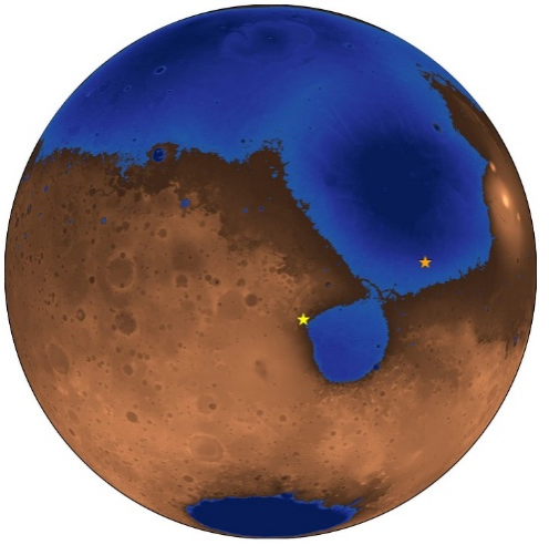
An imaginary image of Mars 3.6 billion years ago. The blue area shows the now-vanished Deuteronilus ancient ocean and coastline. The orange star indicates the landing site of China's Zhurong Mars rover, and the yellow star is the landing site of NASA's Perseverance Mars rover (Image credit: Robert Citron)
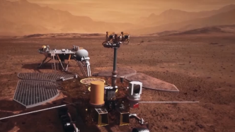
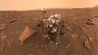
China's first Mars rover, Zhurong, landed in the southern part of Utopia Planitia on May 15, 2021. It is equipped with a Mars subsurface penetrating radar developed by the Institute of Space Information Innovation of the Chinese Academy of Sciences to detect underground structures and possible water ice. The route of Zhurong is about 280 kilometers north of the ancient ocean coastline proposed by predecessors, and the altitude is about 500 meters lower than the coastline.

Map of Utopia Planitia, the landing site of the Zhurong Mars rover, and four possible ancient coastlines
By analyzing the measured data of the low-frequency channel of the Zhurong radar, the research team identified 76 underground inclined reflectors at a depth of 10 to 35 meters below the surface along the rover. These emitters are widely and evenly distributed in space, covering an area of more than 1.3 kilometers. All reflectors are inclined toward the northern lowlands, with inclinations ranging from 6° to 20° and an average inclination of 14.5°. Multiple parallel reflectors can be observed at different depths at the same location. These bedding structures are very similar to the radar imaging results of coastal sediments on Earth. Their consistency and physical properties exclude other causes such as aeolian sand piles, lava tubes or river alluvial deposits. The large-scale existence of these sediments indicates that wind-wave-driven coastal transport provides a stable net inflow of sediment to the coastline and forms a coastline foreset layer. This structure can only be formed in a long-lasting and stable large-scale water environment, rather than just a local and short-lived meltwater phenomenon.
This study not only provides key underground evidence of the existence of an ancient ocean in the northern plains of Mars, but also reveals that Mars once experienced a long period of warm and humid climate, which means that Mars has maintained temperature and pressure conditions suitable for the existence of liquid water for a long time. In addition, the dielectric properties of the coastline sediments found in the study are consistent with the dielectric constants of fine sand and medium sand particles on Earth, which further confirms the nature of its marine sediments.

Comparison of oblique reflections detected on Mars and ocean sediments on Earth (A) Ground-penetrating radar image of coastal sediments in Shark Bay, Australia; (B) Radar profile of the low-frequency channel of the Zhurong Mars Subsurface Penetrating Radar

Schematic diagram of the formation process of the inclined sedimentary structure at the Zhurong landing site (A) Layered structure formed by tidal sedimentation; (B) As the ancient coastline retreated, liquid water disappeared and sedimentation stopped. Subsequent long-term physical and chemical weathering changed the properties of rocks and minerals, leading to the formation of the Martian surface layer. As a result, the sediments were covered by the current Martian surface soil.
The greatest significance of this discovery is that it extends the evidence of liquid water on Mars from the sparsely populated polar regions of Mars to the mid- and low-latitude regions that are more suitable for human activities, proving that Mars was once habitable. If there was an ocean in this area, then as the climate changes, a large amount of water may be sealed in the form of underground ice, which will provide possibilities for the use of water resources for future Mars bases and will greatly reduce the construction and maintenance costs of Mars bases. In addition, these ancient marine sediments preserve the historical records of Mars' climate change. Studying these sediments can help us understand how Mars changed from warm and humid to cold and dry, and then guide humans on how to transform the Martian environment and achieve long-term sustainable habitation on Mars.